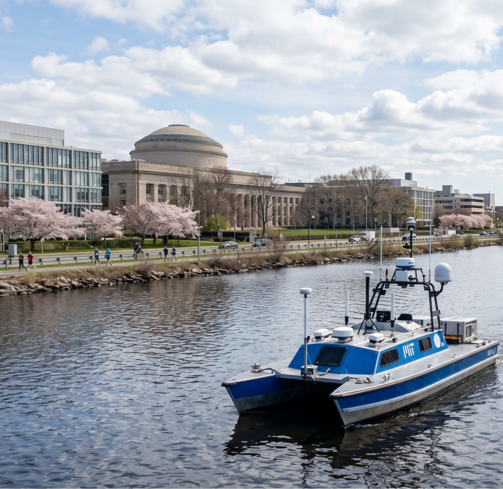
The “REx” developed by the MIT Sea Grant’s AUV Lab, with the Remote Explorer IV (REx IV) unmanned surface vessel (USV).
The “REx”
is part of an ongoing series of autonomous vessels developed by the MIT Sea Grant’s AUV Lab, with the Remote Explorer IV (REx IV) being their flagship unmanned surface vessel (USV).
It is essentially a highly modular, self-driving floating laboratory designed to push the boundaries of marine perception, oceanographic research, and autonomous navigation.
Here is a breakdown of what makes the REx IV operate:
1. The Design: Wave Adaptive Modular Vessel (WAM-V)
The physical foundation of the REx IV is a 5-meter (16-foot) WAM-V catamaran.
Flexibility: Unlike a traditional rigid boat, it uses inflatable pontoons connected to the main payload deck via hinges and dampers. This allows the vessel to literally bend and adapt to the surface of the water, keeping the central equipment deck incredibly stable even in heavy chop.
Transportability: The modular design means the entire vessel can be disassembled for easy transport to various deployment sites, from the Charles River out into Massachusetts Bay.
Propulsion: It is powered entirely by dual electric motors (Torqeedo) mounted on articulating pods, providing clean, quiet, and precise differential steering.
2. The Brain: MOOS-IvP Architecture
The REx IV isn’t just a giant remote-controlled toy; it runs on MOOS-IvP (Mission Oriented Operating Suite with Interval Programming), a specialized autonomy middleware architecture heavily utilized and developed at MIT.
Rather than requiring a human to pilot it via joystick, operators give REx IV high-level directives (e.g., “Survey this grid of the harbor”).
The software calculates thousands of possible speed and heading combinations per second, weighing the mission parameters against real-time collision avoidance rules to navigate safely without human intervention.
3. The Senses: Multimodal Sensor Fusion
To survive in semi-structured environments like Boston Harbor—where it has to deal with human-piloted sailboats, commercial ferries, and drawbridges—REx IV relies heavily on sensor fusion.
Above the Surface: It is outfitted with LIDAR, marine radar, infrared (IR), and high-definition video cameras to detect and classify obstacles.
AIS Integration: It pulls in Automatic Identification System (AIS) data to track the speed and heading of commercial vessels, projecting their paths to avoid collisions.
4. The Mission: Deep-Water Data Gathering
The ultimate goal of the REx IV is to serve as a scientific force multiplier. Gathering oceanographic data traditionally requires expensive manned research ships. REx IV can stay out longer and gather data more efficiently.
The Winch Module: The vessel features a custom automated marine winch system. It can drive itself to a specific GPS coordinate and automatically lower a payload of sensors (or even smaller tethered underwater robots) deep into the water column.
Practical Applications: It has already been successfully deployed to create bathymetric (underwater depth) maps of the Charles River Basin, conduct salinity studies, and monitor for ocean acidification, doing the dull and dangerous work so researchers can focus strictly on the data.
The air off the Charles this morning has that classic mid-April bite—crisp enough to keep your pace up, but carrying the unmistakable scent of a Cambridge spring. As I hit the stretch of pavement at 160 Memorial Drive, I find myself slowing down. It’s hard not to.
To my left, the Great Dome sits stoic, but to my right, the Charles River is acting as a live laboratory. I’m standing directly in front of the MIT Marine Autonomy Lab, and today, the water is busy with more than just the usual sailing larks and crew shells.
The Invisible Fleet
From this vantage point, you realize that “marine research” has evolved far beyond weathered captains and sonar pings. The surface of the water is being cut by sleek, unmanned surface vehicles (USVs), while beneath the chop, autonomous underwater vehicles (AUVs) are running silent, pre-programmed patterns.
These aren’t just high-tech toys. As a jogger, I see the “what,” but as a tech enthusiast, I’m fascinated by the “how.” The research happening inside these doors is a masterclass in multi-domain mastery. To make a robot navigate the Charles—with its unpredictable currents, debris, and recreational traffic—requires a fusion of:
Acoustic Communications: Because GPS doesn’t work underwater, these systems have to “talk” using sound waves.
Edge Computing: The “brain” of the vessel has to make millisecond decisions without waiting for a cloud server.
Environmental Sensing: Mapping the riverbed in real-time to adjust for shifting silt or obstacles.
Why the Charles is the Ultimate Classroom
There’s a reason the Marine Autonomy Lab is situated right here. The Charles River provides a complex, “semi-structured” environment. It’s not the open ocean, but it’s certainly not a swimming pool.
Education here is hands-on. Students aren’t just staring at Python scripts in a windowless room; they are on the docks, calibrating thrusters and debugging hydrophones. This is where succession and continuity in engineering are born. We are watching the next generation of polymaths learn to command the physical world through the digital one.
Beyond the Horizon: 2026 and Beyond
As I check my watch and prepare to pick the pace back up toward the Longfellow Bridge, I can’t help but think about the long-term trajectory. By the year 3000, will the concept of a “piloted” ship be as ancient as a trireme?
The work at 160 Memorial Drive suggests a future where our oceans are monitored by autonomous sentinels—protecting ecosystems, managing logistics, and perhaps even mitigating the catastrophic climate events we’ve seen throughout history. Whether it’s a tsunami warning system or autonomous defense, the blueprints are being written right here in the wakes of these tiny, robotic boats.
The Takeaway for the Morning Run:
Next time you’re pounding the pavement on Memorial Drive, take a second to look at the water. You aren’t just looking at a river; you’re looking at the testing ground for the future of planetary stewardship.
Back to the rhythm. 45 years old and still outrunning the machines—for now.
Part of an ongoing series of autonomous vessels developed by the MIT Sea Grant’s AUV Lab, with the Remote Explorer IV (REx IV) being their flagship unmanned surface vessel (USV).
It is essentially a highly modular, self-driving floating laboratory designed to push the boundaries of marine perception, oceanographic research, and autonomous navigation.
Here is a breakdown of what makes the REx IV operate:
1. The Design: Wave Adaptive Modular Vessel (WAM-V)
The physical foundation of the REx IV is a 5-meter (16-foot) WAM-V catamaran.
Flexibility: Unlike a traditional rigid boat, it uses inflatable pontoons connected to the main payload deck via hinges and dampers. This allows the vessel to literally bend and adapt to the surface of the water, keeping the central equipment deck incredibly stable even in heavy chop.
Transportability: The modular design means the entire vessel can be disassembled for easy transport to various deployment sites, from the Charles River out into Massachusetts Bay.
Propulsion: It is powered entirely by dual electric motors (Torqeedo) mounted on articulating pods, providing clean, quiet, and precise differential steering.
2. The Brain: MOOS-IvP Architecture
The REx IV isn’t just a giant remote-controlled toy; it runs on MOOS-IvP (Mission Oriented Operating Suite with Interval Programming), a specialized autonomy middleware architecture heavily utilized and developed at MIT.
Rather than requiring a human to pilot it via joystick, operators give REx IV high-level directives (e.g., “Survey this grid of the harbor”).
The software calculates thousands of possible speed and heading combinations per second, weighing the mission parameters against real-time collision avoidance rules to navigate safely without human intervention.
3. The Senses: Multimodal Sensor Fusion
To survive in semi-structured environments like Boston Harbor—where it has to deal with human-piloted sailboats, commercial ferries, and drawbridges—REx IV relies heavily on sensor fusion.
Above the Surface: It is outfitted with LIDAR, marine radar, infrared (IR), and high-definition video cameras to detect and classify obstacles.
AIS Integration: It pulls in Automatic Identification System (AIS) data to track the speed and heading of commercial vessels, projecting their paths to avoid collisions.
4. The Mission: Deep-Water Data Gathering
The ultimate goal of the REx IV is to serve as a scientific force multiplier. Gathering oceanographic data traditionally requires expensive manned research ships. REx IV can stay out longer and gather data more efficiently.
The Winch Module: The vessel features a custom automated marine winch system. It can drive itself to a specific GPS coordinate and automatically lower a payload of sensors (or even smaller tethered underwater robots) deep into the water column.
Practical Applications: It has already been successfully deployed to create bathymetric (underwater depth) maps of the Charles River Basin, conduct salinity studies, and monitor for ocean acidification, doing the dull and dangerous work so researchers can focus strictly on the data.